HUDSON COUNTY – It’s being called the Perfect Storm by some meteorologists. Others have dubbed it “Frankenstorm” because the anticipated frightful weather will hit Halloween week.
Whatever it’s called, if the worst case scenarios play out as they could, it will be a mess for residents up and down the East Coast, including people in the New York metro area, which includes Hudson County.
Three storm systems are expected to converge in the Atlantic Ocean early this week and together they could wreak havoc on states from Virginia up to Ohio. The remnants of Hurricane Sandy are coming up from the south and could hit our area as a Tropical Storm. A cold air mass is barreling down from Canada in the north while a winter storm is brewing out west. If this unholy trinity meets, meteorologists predict we could be in for a storm with at least five inches of rain and wind gusts of up to 70 miles per hour that could leave $1 billion worth of its wake.
In preparation for the “Perfect Frankenstorm” (our name for it), municipalities throughout Hudson County are planning for heavy flooding, possible evacuations, shelter needs, and other emergency services. Most cities in Hudson County were still solidifying their plans at press time Friday. As a rule of thumb, most municipalities are urging residents to immediately sign up for their reverse 911 systems so they can be apprised of weather-related updates. Residents can sign up for these services by visiting their municipal websites.
In Hoboken, visit www.hobokennj.org/emergency. Residents may also sign up for non-emergency related alerts at www.hobokennj.org/alerts. The city is calling for as many volunteers as possible as early as tomorrow, to help get the word out and man call centers so that the police and fire departments can concentrate on emergency calls. Volunteers will be meeting Saturday at 221 Jackson St. at 11 a.m. and also Sunday at City Hall at 11 a.m. At this time, the city is not calling for an evacuation, but residents in ground floor and basement apartments are encouraged to start thinking about where to go just in case. If need be, shelters will be set up at Wallace School and a back-up shelter will be at Hoboken High School.
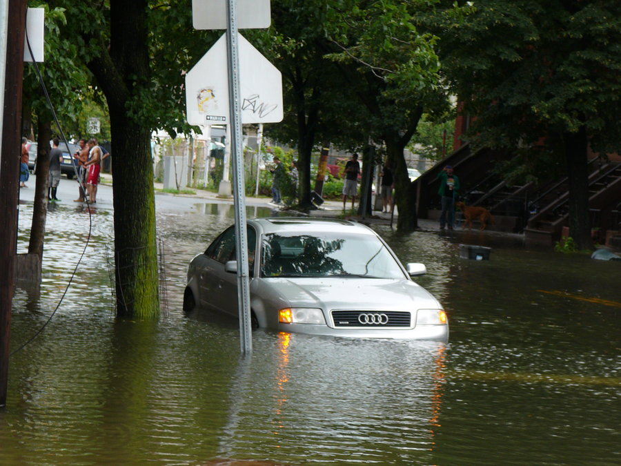
In Jersey City, sign up for the city’s C3 Alert system at https://jerseycitynj.my.gov-i.com/signup. Officials here and in Hoboken said late last week that they have cleaned out catch basins and are preparing shelters in case residents need to be evacuated from their homes. In the event of evacuations, Jersey City officials have already said there will be one pet-friendly shelter open at Pershing Field. Jersey City is also stockpiling sandbags for residents to use to stave off rising water in low-lying areas. The city will alert residents as to where they can get sandbags later this weekend. Residents can call the Jersey City Municipal Utilities Authority at (201) 432-1150 to report a clogged catch basin.
Jersey City and Hoboken residents who typically park in flood-prone areas are being asked to park elsewhere during the storm.
The town of Secaucus is instructing residents to follow developments on local cable Channel 36, or they can visit the town website www.secaucusnj.org for updates. Secaucus residents should listen for the town wide alert system located in the Plaza and on Koelle Boulevard, Laurel Hill, and Secaucus Road. In the event of an evacuation, Secaucus has already identified Huber Street School as the town’s designated shelter.
Secaucus residents can call their local Office of Emergency Management at (201) 864-1061 or call the Secaucus Police Department non-emergency number at (201) 330-2060 .
Officials in Weehawken are reminding their residents that they can call the Department of Public Works if they see experience flooding or see downed power lines or tree limbs at (201) 319-6050 . The Weehawken police non-emergency number is (201) 863-7800 .
Residents throughout Hudson County who have loose furniture or unsecured items outside their homes are urged to either take those items indoors or secure them with sturdy rope. Officials are also recommending that residents clean out gutters ahead of the storm.
In West New York, the Middle School, located at 201 57th St., will be on call as the town’s shelter and will be fully stocked with food, water, and accommodations for hundreds of people should evacuations be necessary. Ahead of the storm, Police Director Michael Indri toured the town and ordered removal of loose branches and garbage that could cause problems in the event of high winds.
Union City has also identified a shelter if residents need to be evacuated from their homes. The Jose Marti Freshman Academy, at 1800 Summit Ave. will be the city’s designated shelter and will be staffed by the Red Cross and the local Community Emergency Response Team beginning at 10 a.m. Monday. The shelter has 240 cots on hand, with food and water available as necessary.
Union City Police Chief Brian Barrett said residents should check the city web site often for updates regarding evacuation plans, if necessary.
In North Bergen, there has been a preliminary decision to open two shelters, North Bergen High School, at 7417 Kennedy Blvd., and John F. Kennedy School, at 1210 11th St. A final decision on whether or not to open the shelters will be made on Monday and is dependent on the track of the storm, along with weather reports over the coming days. Information will be disseminated to residents via the township website, the NB Connect system, and Reverse 911. Residents with any questions are urged to call the Police Department at (201) 392-2100 .
In Guttenberg, Public Safety Director Michael Caliguiro said that generators, and other equipment that would aid in the event of an emergency, are standing by. They have been checked and are fully functional.
Waterfront residents have been notified of precautionary measures that they should take in the likely case that the tide rises from the Hudson River. High rise buildings have also been alerted, although each has their own emergency plans. They have also been told to clear their roofs or terraces of anything that may harm residents when the storm hits New Jersey. Palisade Nursing Center has been contacted as well which purchased a generator in the event of an emergency. Police officers will be stationed near the waterfront in case conditions on the waterfront become an issue during the storm.
The Town of Guttenberg web site states that the town has an “excellent emergency phone system, where we will be able to contact you with information and direction in the case of an emergency.”
The Anna L. Klein School, located on 69th Street, has been placed on stand-by as a possible emergency shelter.
In the event of a power outage, contact PSE&G at (800) 436-PSEG (7734) directly.
Emergency prep advice from FEMA
The Federal Emergency Management Agency (FEMA) recommends that families make sure they have evacuation plans in place and emergency items – such as flashlights, extra batteries, bottled water, nonperishable food, first aid kits, prescription medication, and battery operated radios – handy in case the area loses power. In the event of an evacuation scenario, pack an emergency bag before the storm comes. Locate and centralize important papers, in case your family is forced to evacuate.
Put gas in vehicles before the storm hits and keep cell phones fully charged.
Be sure to check on elderly neighbors and others who may have special needs in case they require assistance evacuating or getting help during the storm. Be particularly sure to remain in contact with relatives and neighbors who may not have access to the internet or social media and who may have difficulty getting timely updates regarding emergency alerts.
Late Friday afternoon U.S. Sen. Robert Menendez (D-NJ) announced a web site link the will be a centralized location for updates on the storm. The Hurricane Sandy Resource Center includes comprehensive information and links to resources from national, state and local governments, news media, weather services and other organizations. The web page features Twitter feeds from FEMA, the NJ Office of Emergency Management, the Red Cross, and others which will provide real-time updates on the hurricane. Visit the Hurricane Sandy Resource Center at www.menendez.senate.gov/hurricanesandy.
“As we track this potential super-storm, I encourage families to stay together,” Menendez said Friday. “Please take special care to look in on elderly or disabled neighbors and friends. Let’s all do our best to look out for each other.”
This is a developing and changing weather event. Check www.HudsonReporter.com for updates. – E. Assata Wright