HOBOKEN — Flooding in Hoboken – a mile-square city along the Hudson River – is something residents have gotten used to, since the city is at sea level in areas, and has an antiquated “combined sewer system” that carries rain and sewer water at the same time. Over the last few years, the city has addressed the problem with new flood pumps and sensors, but a hurricane making a direct hit to New Jersey is a rare occurrence.
This recent story in the Hudson Reporter, based in Hoboken and Bayonne, described the situation and what has been done lately to address the problems. If a hurricane made landfall in the New York City/Hoboken area, and the storm was greater than category 1, bigger problems could occur, as this story describes. This story was written before the new flood pumps were added.
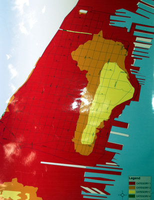
The map, released last year before Tropical Storm Irene, shows where Hoboken would flood.
Our Digital Archive from 2000 – 2016