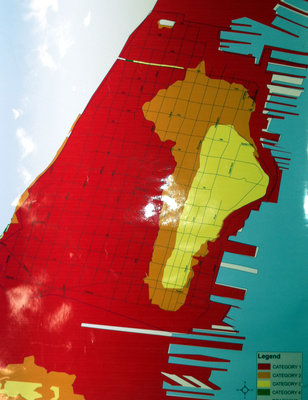
HOBOKEN — Besides warning Hoboken residents to leave town before Hurricane Irene hits (see prior news items below at hudsonreporter.com), the town released a map of areas that may flood during the storm — which is currently projected to hit New Jersey on Sunday morning.
The map shows an area that would flood if a Category 1 hurricane, the weakest storm, hits. That area is almost all of town except the higher areas around Washington Street and the Stevens Institute of Technology on Castle Point. The area expands if the storm is strong enough to be a Category 2, and all of Hoboken is shown to be flooded if a powerful Category 3 hits.
The city has also announced emergency shelters and busing for those who can’t leave town. See the city’s website here for more. Keep watching hudsonreporter.com, the Hudson Reporter newspaper group in Hoboken, New Jersey, for further updates.
Our Digital Archive from 2000 – 2016
