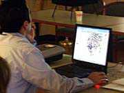
A computer terminal sat at the front of the Panasonic meeting room projecting images onto a large screen. One showed the footprint of a building in the south end of Secaucus, while others displayed the location of a flood plane and even the emergency route through the streets should the building report a fire.
The man at the computer was demonstrating a new high-tech digital mapping system that is expected to revolutionize access to information in Secaucus and other parts of the Meadowlands District.
Municipalities throughout the Meadowlands District will have access to this state-of-the-art tool called the Geographic Information System (GIS). The system, first used by the New Jersey Meadowlands Commission (NJMC), will be able to provide visually explicit information about a town or selected area. The information will help local municipalities with zoning, planning, and community safety.
Over time, all 14 towns in the Meadowlands District will be able to access information about their own towns, from ownership of a parcel of land to the location of the nearest fire hydrant. This is expected to help enhance each community’s ability to plan.
If a fire should break out, a firefighter can access the system from a portable computer hooked up to the internet, learn the width of local streets to see if a fire truck can get through, whether or not nearby buildings pose a risk as far as incendiary materials, and even where the fire truck can access a fire hydrant.
Some information, because of security concerns, will only be accessible by use of a password, although much of the land use information and other aspects will be accessible to the general public via the internet.
Secaucus gets it first
Secaucus was chosen for the demonstration because it is the first community to go on line.
“Mike Gonnelli worked very hard to get this up and running,” said Secaucus Mayor Dennis Elwell. “There were other communities that declined to be first, saying it was too much work. But Mike went right at it.”
Through this system, various municipal departments including law enforcement and firefighters will be able to combine detailed land information from images taken by satellite with Census 2000 data and local municipal contributions and turn these statistics into visual problem-solving tools.
“This new tool highlights our dedication to fostering a better quality of life for the residents of the Meadowlands through smart local government,” said Susan Bass Levin, commissioner of the New Jersey Department of Community Affairs and chairman of the New Jersey Meadowlands Commission (NJMC).
Geographical Information Systems
The Meadowlands Environmental Research Institute Geographical Information System (GIS) is an advanced mapping and land information management system that stores information and generates details maps and analysis for scientists and decision-makers.
Four full-time GIS specialists will store the information in a separate database for each town. Local officials will have instant access to their own information, but can also request a cross link to other communities if necessary.
The NJMC has overseen development decisions in the Meadowlands region, and through this program, is dedicating an average of $25,000 to each municipality in services, hardware and software to help the town access and contribute to the mapping system.
“The cost of such a system is usually beyond the reach of many of the municipalities in the Meadowlands District,” said NJMC Executive Director Bob Ceberio. “Under our partnership, this state-of-the-art tool for land use planning is now available to all.”
Starting with Secaucus, towns throughout the Meadowlands District will have high-speed access to a mapping database located at the NJMC’s Lyndhurst offices and compiled from paper maps and other geographical documents available at a local and state level.
Although Secaucus is first, Carlstadt is not far behind, and work has begun in Jersey City and North Bergen as well. Municipalities will be able to access a variety of information from tax maps to emergency service.
There will be information on government buildings, police stations, firehouses, schools, hospitals, the Census, property, flood control, fire hydrant locations, street addresses, high resolution aerial photographs, transportation nodes, building foot prints, elevation codes, hydrology and more. From the database, police, firefighters, EMS, public utilities, public works departments, safety officers, and others can search for property information, locate buildings, check on municipal manholes, determine the age of structures, track school demographics and performance, and plan shelter and evacuation procedures. NJMC officials said this system would benefit about 494,000 people in Northern New Jersey and would be continuously updated.
Ceberio said this is a tool that can have many uses, from crime-fighting to battling blazes.
This information source can also be plugged into existing information systems, something that had concerned Secaucus Police Captain Richard Scalzo, who said the police have an up-to-date information system of their own.
“I came to find out if we can bring that information into our system,” he said. “It seems we can.”
Our Digital Archive from 2000 – 2016