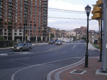
Hudson County planners have commissioned a year-long study of the traffic patterns on the Jersey City-Hoboken border near Paterson Plank Road to ease congestion and to recommend how to accommodate vehicles, cyclists, and pedestrians.
The Jersey City/Hoboken Sub-regional Transportation Study started in June and will end in June 2011. The $300,000 study is being funded by the North Jersey Transportation Planning Authority (NJTPA) and will be created by the firm Eng-Wong, Taub with assistance from Howard/Stein-Hudson, SHP and AKRF.
The study area encompasses the top of the Palisade hills in Jersey City, from Palisade Avenue on the west to Paterson Plank Road on the east, and from Franklin Street on the north to New York Avenue on the south. At the foot of the Palisades, where Hoboken and Jersey City meet, the study area continues from Paterson Plank Road on the west to Willow Avenue in Hoboken on the east, and from Second Street in Hoboken on the north to 18th Street in Jersey City on the south.
“We are looking at the connectivity between the two towns, improving circulation.”— Megan Massey
________
Megan Massey, the head planner for Hudson County, said the survey will recommend how to accommodate cars, cyclists, buses, and pedestrians.
“We are looking at the connectivity between the two towns, improving circulation,” Massey said. “It is about looking at all aspects.”
New development coming
The study comes at a time when development in the area is moving forward.
Van Leer Place, a 7-acre project on Hoboken Avenue in Jersey City, will include more than 480 homes in two buildings when completed in 2015. The developers have also planned 8,700 square-feet of retail space and on-site parking.
Also, Hoboken residents have pushed for a 6-acre park in that area as part of a proposed redevelopment zone that could also include more housing.
Importance of study
Two open house meetings in Hoboken and Jersey City took place in June, Massey said. Residents gave suggestions for traffic improvements near the border. Massey said suggestions from attendees who live in the area included more bike lanes, more sidewalks, and cutting down on cars making left turns that slow traffic.
Hoboken Councilman Michael Lenz, who represents the city’s 4th Ward, much of which is included in the study, said he hopes the study will produce positive outcomes for the area. Lenz said he has a “personal stake” in providing input that will lead to safer streets. A few years ago, his wife and his son were driving in a car that was struck by another car near the corner of Harrison Street and Paterson Plank Road.
Both were uninjured, but Lenz said two factors contributed to the crash: poor visibility due to a construction container parked at the corner, and more importantly, a lack of traffic signals.
He also said a study of pedestrian travel is “absolutely crucial.”
Lenz commended county officials for working with Hoboken officials to carry out the study, and said it is happening at the “right time” for his ward.
“Before we do any redevelopment in that part of Hoboken,” Lenz said, “we need to understand the impact of traffic on that redevelopment. That to me is a responsible way to proceed.”
To learn more about the study, visit http://www.jerseycityhobokenstudy.com.
Ricardo Kaulessar can be reached at rkaulessar@hudsonreporter.com.
