
The tax maps of North Bergen created during the early 1900s – hand-drawn and color-coded – are far more detailed than those today, displaying an amusement park, streams that are now roads, and a pig pen.
These artistic renderings could have been lost to the township if they had not been found several years ago when Town Hall renovated its basement.
The books of maps, most suffering from some degree of water damage, are now safeguarded in the North Bergen Tax Assessor’s office. They were originally produced by Hudson County and replaced every 20 years, ranging from 1909 to the 1960s.
“It [would be] criminal to throw them away.” – Edward Giunta.
________
“It [would be] criminal to throw them away,” said Giunta.
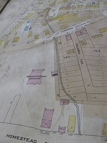
Streams, orphanage, pig pen
Tax Assessor Paul Sadlon pointed out that the maps show how the township has changed over the last 100 years.
In a tax book that tracked the changes to North Bergen from 1910 through 1935, a stream ran past Patterson Plank Road where Bergen Turnpike is today.
Giunta said that this stream is just one of many bodies of water that no longer exist. He said that 77th Street was also once a stream. Also, a little over 100 years ago, a pond lay a few blocks from where Town Hall stands today.
Several buildings of yesteryear are long gone, but renditions of these places still exist on the maps. The Shoprite at Columbia Park, located at 3147 Kennedy Blvd., is on land that was once the Columbia Amusement park. In a book dated from 1910-1935, the park is depicted as having two roller coasters, water reservoir, swimming pool, shooting gallery, boardwalk, dance pavilion, merry go-round, and racetrack.
One page depicts Tonnelle and Liberty avenues as empty parcels of land with almost no buildings on them. Sadlon said that this part of the township was once farmland.
Other maps depict The Barbara Givernaud Orphanage, which existed East of Paterson Plank Road. Residential homes are there now.
A horse hospital, shooting range, beer garden, slaughter house, and a pig pen are just a few of the other buildings that are noted on the maps.
Just a few weeks ago, Sadlon showed North Bergen High School students the maps during Law Day.
“They loved it,” said Sadlon. “They thought it was great. They were really interested and really looking through them [to see] what the town was years ago.”
Dog tax was $16
When the tax assessor’s maps were found, tax ledgers from the 1800s were also unearthed.
One book was written by the then town clerk in handwriting that looks like calligraphy beginning on Jan. 3, 1880. The township was incorporated from Bergen on April 10, 1843.
It starts off with the amount of annual taxes, with state tax being $172, the state school tax at $684.11 and county tax at $795.29. There was even a dog tax at $16.
Inside the ledger was a local notice of the sale of land by the township, published in 1879.
Tricia Tirella may be reached at TriciaT@hudsonreporter.com.